-40%
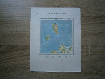
1892 Perron map MANITOU ISLANDS, NEAR LEELANAU PENINSULA, LAKE MICHIGAN (#12)
$ 10.53
- Description
- Size Guide
Description
Perron16_0121892 Perron map MANITOU ISLANDS, NEAR LEELANAU PENINSULA, LAKE MICHIGAN (#12)
Nice small map titled
Iles Manitou
, from wood engraving with fine detail and clear impression, nice hand coloring. Overall size approx. 19 x 16 cm, image size approx. 11 x 10.5 cm. From:
Les Etats Unis
, volume no. 16 of
La Nouvelle Géographie universelle, la terre et les hommes
, 19 volumes (1875-94), great work of Elisee Reclus. Cartographer is Charles Perron.
North Manitou Island
North Manitou Island is located in Lake Michigan, approximately 12 miles (19 km) west-northwest of Leland, Michigan. It is nearly eight miles long and over four miles (6 km) wide, with 20 miles (32 km) of shoreline. It has a land area of 57.876 km2 (22.346 sq mi) and has no population. The smaller South Manitou Island lies to its southwest.
North Manitou Island is shaped like an upside-down teardrop, with the now-forested body of the 'drop' surrounding Lake Manitou, and the tail of the drop narrowing into sandy, exposed Dimmick's Point on the island's southeastern extremity. The ferry dock and ranger station are on the island's central eastern shore, directly east of Lake Manitou.
The island is in Leelanau County and is part of the Sleeping Bear Dunes National Lakeshore, although it is over 6 miles (9.7 km) offshore. Park passes and camping fees are required. The island can be accessed by a ferry service from Leland; private watercraft are permitted with limited docking. No wheeled vehicles are allowed on the island other than those used by the National Park Service or to cart off a dead deer. No campfires are allowed on the island except at public firepits near the ranger station. Similarly there is only one water spigot, and one outhouse, in the same area.
South Manitou Island
South Manitou Island is located in Lake Michigan, approximately 16 miles (26 km) west of Leland, Michigan. It is part of Leelanau County and the Sleeping Bear Dunes National Lakeshore. The uninhabited island is 8.277 sq mi (21.44 km2) in land area and can be accessed by a ferry service from Leland. Guided tours on open-air vehicles are available to visitors, but most traffic is on foot. Larger North Manitou Island lies to its north.
The island is 3 miles (4.8 km) wide and 3 miles (4.8 km) long. It is part of an island chain that extends north to the Straits of Mackinac. The island consists of a ridge of tilted layers of limestone, buried under a blanket of glacial debris. Glaciers carved out the Lake Michigan basin. When the basin filled with water, the peaks of the ridge remained exposed as islands. During post-glacial times, winds blowing on the high, sandy bluffs on the west side of the island moved sand inland, forming sand dunes. Florence Lake is the island's only inland lake. The island has a system of trails and campsites.
A growth of Northern white cedars on the southwestern corner of the island are among the oldest and largest in the world. The largest is 18 ft (5.5 m) around and is estimated to be over 500 years old.
